We woke up today in Lexington, Nebraska with an unknown destination; other than knowing the direction, SW. We traveled for 10 hours straight finally arriving somewhere on the eastern side of New Mexico. Storms were firing during the early afternoon and our chase team decided to head further southwest. We ended up driving all day thinking it would be a bust, however we got on a classic super cell. This storm produced a nice gust front which brought up large masses of dust. Winds were extremely strong reaching 60 mph. Our professors decided to put us in the middle of this gust front driving straight through, there was no visibility.
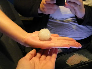
The storm began to strengthen and you could see the hook on the back of the storm on radar. Base Velocity showed a small couplet and shear markers were indicated. A TVS was also issued for this storm and it soon went from a severe thunderstorm warning to a tornado warning. Ping pong to golf ball size hail was reported. Trained chasers had spotted a brief tornado with this cell. On the other hand, we were on the back side of the storm and did not get to witness the touch down. From our view the storm was wrapped in rain and the sun had already started to go down making it even harder to view any type of touch down.
We arrived in Clovis, New Mexico to settle down for the evening and eat some dinner at IHOP! No place better to eat breakfast at mid night. While at dinner winds began to pick up and lightning became more prevalent. Arriving back at the hotel rain began to fall and soon after pea size hail began to fall. Flash flooding was also becoming a concern.


No comments:
Post a Comment