The last two days we traveled many miles home from Amarillo, Texas. I was able to witness some of the most beautiful landscapes painted by the hand of God as I traveled back home; from ranches to black hill and sand hills, to the rocky mountains, to sulfur lakes. I can now say that I have traveled through 14 states in 15 days in nearly 8000 miles. This will definitely be a trip to remember!
Saturday, June 16, 2012
6/13/2012
Clovis, New Mexico is where I woke up this morning even more tired than any other day before. Everyone was becoming irritated at the fact that we hadn't seen a full on tornado! We drove to Roswell, New Mexico were we stopped to fill up on gas. Usually this is an uneventful task, but today was a day filled full of excitement. The Dominator showed up at the same gas station. For those of you who may not know who drives The Dominator, his name is Reed Timmer. Reed is the lead chaser of the TV series Storm Chasers.
As we went throughout our day, the area was forecasted with a slight risk and a 2 percent chance of seeing a tornado. There was one storm that caught our eye, which was the same storm Reed was chasing. The storm however was a bust and so was the rest of the day. We ended up just admiring the natural landscape of New Mexico, which mostly consisted of rock and cactus. The temperatures were mostly in the upper 80's and mid 90's with dry air, making it feel so amazing outside. Since we were so used to the moist air, making temperatures feel like they are in the upper 90's to 100 degrees.


As we went throughout our day, the area was forecasted with a slight risk and a 2 percent chance of seeing a tornado. There was one storm that caught our eye, which was the same storm Reed was chasing. The storm however was a bust and so was the rest of the day. We ended up just admiring the natural landscape of New Mexico, which mostly consisted of rock and cactus. The temperatures were mostly in the upper 80's and mid 90's with dry air, making it feel so amazing outside. Since we were so used to the moist air, making temperatures feel like they are in the upper 90's to 100 degrees.


Wednesday, June 13, 2012
6/12/2012
We woke up today in Lexington, Nebraska with an unknown destination; other than knowing the direction, SW. We traveled for 10 hours straight finally arriving somewhere on the eastern side of New Mexico. Storms were firing during the early afternoon and our chase team decided to head further southwest. We ended up driving all day thinking it would be a bust, however we got on a classic super cell. This storm produced a nice gust front which brought up large masses of dust. Winds were extremely strong reaching 60 mph. Our professors decided to put us in the middle of this gust front driving straight through, there was no visibility.
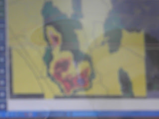
The storm began to strengthen and you could see the hook on the back of the storm on radar. Base Velocity showed a small couplet and shear markers were indicated. A TVS was also issued for this storm and it soon went from a severe thunderstorm warning to a tornado warning. Ping pong to golf ball size hail was reported. Trained chasers had spotted a brief tornado with this cell. On the other hand, we were on the back side of the storm and did not get to witness the touch down. From our view the storm was wrapped in rain and the sun had already started to go down making it even harder to view any type of touch down.
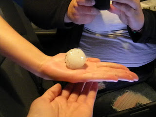
We arrived in Clovis, New Mexico to settle down for the evening and eat some dinner at IHOP! No place better to eat breakfast at mid night. While at dinner winds began to pick up and lightning became more prevalent. Arriving back at the hotel rain began to fall and soon after pea size hail began to fall. Flash flooding was also becoming a concern.


The storm began to strengthen and you could see the hook on the back of the storm on radar. Base Velocity showed a small couplet and shear markers were indicated. A TVS was also issued for this storm and it soon went from a severe thunderstorm warning to a tornado warning. Ping pong to golf ball size hail was reported. Trained chasers had spotted a brief tornado with this cell. On the other hand, we were on the back side of the storm and did not get to witness the touch down. From our view the storm was wrapped in rain and the sun had already started to go down making it even harder to view any type of touch down.
We arrived in Clovis, New Mexico to settle down for the evening and eat some dinner at IHOP! No place better to eat breakfast at mid night. While at dinner winds began to pick up and lightning became more prevalent. Arriving back at the hotel rain began to fall and soon after pea size hail began to fall. Flash flooding was also becoming a concern.


Monday, June 11, 2012
6/10/2012
Today we traveled a short distance to southwest Minnesota, because the SPC issued a 5 percent chance of tornadoes, along a squall line. Conditions looked good and by early afternoon storms had already began to fire. A meso discussion was issued and informed us that there was an 80 percent chance of issuing a watch.
The cold front was the main focus on these storms. Advancing into late afternoon, a well defined squall line had formed. A severe thunderstorm watch had been issued and soon after, plenty of severe thunderstorm warnings were issued. The main threat for these storms were wind and hail.
We chased for several hours learning of how squall lines form and what they look like in the sky, for example the clouds will roll and shelf out. As the evening progressed, we went to dinner and saw that the storms were building and heading toward our location, Mankato, MN. A tornado warning was issued just north of our current county. Storms passed throughout the evening and temperatures dropped.
 Shelf and Roll clouds out ahead of a squall line.
 Storms firing

God's eye!
The cold front was the main focus on these storms. Advancing into late afternoon, a well defined squall line had formed. A severe thunderstorm watch had been issued and soon after, plenty of severe thunderstorm warnings were issued. The main threat for these storms were wind and hail.
We chased for several hours learning of how squall lines form and what they look like in the sky, for example the clouds will roll and shelf out. As the evening progressed, we went to dinner and saw that the storms were building and heading toward our location, Mankato, MN. A tornado warning was issued just north of our current county. Storms passed throughout the evening and temperatures dropped.


6/8/2012
Casper, Wyoming is where our team woke up in hopes to chase
in eastern Montana. This location was issued a 5 percent chance of seeing a
tornado. As we drove throughout the day the initiation time became unclear.
Models were showing different times and no one really knew what to expect. A
severe thunderstorm watch was issued during late afternoon and a few storms
fired up in the northern parts of Montana heading toward Canada. The storms
weren’t of any significance. By evening hours everyone on the team was
exhausted and we decided to stop chasing for the day.
Friday, June 8, 2012
6/7/2012
Starting location was Cody, Wyoming where we woke up and
left to head toward the Nebraska panhandle.
This was our prime location for chasing since the SPC gave it a five
percent chance of producing a tornado. Our destination was 6 hours from where
we started in Wyoming.
Storms
began firing around 12 p.m. Mountain Time in eastern portions of Wyoming. A watch was issued fairly early in the day. By the time we reached Nebraska around 2 p.m.
Mountain Time storms were really starting to fire. The first tornado warning
was issued around 3 p.m. location was Platte co. Wyoming. Originally we were
headed toward this storm until a second storm formed just south east of the
warned storm. This storm showed signs of progression and strengthening. The
team decided to go ahead and chase after the developing storm; however this
storm slowly died out. Our next step was to figure out how to get back to the
original storm. We headed west and then back north toward this monster storm
with TVS and strong shear. As we started heading north a new storm started to
develop, we were sure to core punch this storm before it decided to intensify. This
storm grew quickly and started to show rotation, TVS was indicated. We followed
this storm for most of the evening, not letting us down completely; the storm
dropped a brief tornado and had great structure. The mesocyclone was well
developed and the wall cloud was very easy to see. Scud was moving into the storm showing signs
of strong inflow. This storm never did drop a tornado after the first brief
touch down, but it kept its structure very well. After a while, the entire meso
was rotating and became rain wrapped.
Soon
after we gave up on following storm, we noticed rotation on another cell just
east of that storm. Two mesocylones were very prevalent and we positioned
ourselves in the middle of the two. This was one of the most beautiful sights I
have ever seen. As we headed out of the super cells we drove straight into the
storm that spun a brief tornado. The mesocyclone was positioned right above us
and the clouds were still rotating.
Storm
reports from the SPC indicated hail up to four inches and a major tornado. This
tornado was not yet rated. As we continued throughout our evening we headed
toward Cheyenne, Wyoming for dinner where I witnessed some of the most
impressive lightning. Then to Casper, Wyoming; on our way we saw slight damage
and hail which had gathered on the side of the road. Storms will continue
throughout the evening in the southeastern portion of Wyoming.


6/5/2012
Starting in Rapid City, South Dakota we left around 7:30 a.m. Mountain time. Our forecast showed a slight chance for severe weather in mid parts of Montana, with a 5 percent chance of tornadoes according to the SPC. Construction made it hard for us to make good timing for initiation.
Traveling into Wyoming we were welcomed with a herd of cattle and their ranchers. Wyoming is very vacant, mostly open territory with a very low population. Indian reserves were common. Most Indians now open up casinos and other attractions to help with their towns.
Coming close to Montana, a sever thunderstorm watch was issued for the southern portion. Storms soon began to fire into intense super cells, and we were in the perfect location just west of Billings. The first storm we were chasing was decent and had small amounts of shear, allowing it to have good structure. However, a new storm formed to the north of us and began to grow with great shear. This storm hit White Sulfur Springs. This storm dropped one weak tornado, however we didn't witness it; we saw small amounts of damage coming into the outskirts of the town.
More storms began to fire around us and before we knew it, we were stuck between 3 super cells. The first storm we were tracking had since grown into a fantastic cell. The shear readings were close to 80 and you could actually see the storm on radar rotating. Chasing this storm was down right impossible! Our road connections were limited and we were located in mountainous terrain.
We decided it was far too dangerous to chase this monster. We needed to focus more on how we were going to get out of the situation we put ourselves in. Wind, rain, and hail made it almost impossible to see especially in the mountains.
To end the day we came to conclusion that we really had no chance of getting to chase the original cell. The road network was a mess. We instead headed to Great Falls, Montana where we ate dinner and spent the night.
As we got to the hotel more storms were training over Great Falls. A few had shear indicators and one with a TVS indicator. Lightning was also a dangerous contributor to the storms. God sure knows how to put on a show!


Wednesday, June 6, 2012
6/4/2012
Waking up in Dodge City, KS the team decided that we should
use this day a positioning opportunity. We left Dodge City heading north.
Making our way through Kansas there weren’t many towns and if there were, they
were very small with signs of poverty. Populations were often small and towns
mostly consisted of a gas station, a possible local market, and a court house. Traveling
into Nebraska, the sand hills soon made an appearance, making for a beautiful
landscape. These hills continued throughout the entire west half of the state
ending as we reached the northern portions of Nebraska. As we entered South
Dakota we noticed a change in the type of soil, from NE sand to SD stone. The
black hills and Mount Rushmore are the main attractions for this state and are
extremely beautiful. However, I did not get to witness Mount Rushmore.


When we reached the hotel I had to privilege to meet a couple from the 6th generation of the Crazy Horse Tribe. They told us a bit about their past and their challenges with other tribes. I absolutely love getting to know more about different types of cultures and environments, and being able to better understand someone else' view on life.
Monday, June 4, 2012
6/3/2012
Morning discussion led to the conclusion that we need to head toward eastern Kansas. However, mother nature always turns on us! We ended up traveling the opposite direction to chase along a dry line in the midst of the Oklahoma and Texas panhandle. Storms had all the right ingredients to form. Dew points were in the 70's, temperatures reached close to 100 degrees Fahrenheit, heat index reached around 105 degrees. Storms didn't start firing until around 5 p.m. central time. Initiation was supposed to be around 20Z. A small single celled storm formed in the Oklahoma panhandle and we began chasing. The storm showed what seemed like a small couplet in the lower left corner, it soon dissipated. Storms in front of this dry line were firing and then dissipating, because of the weak shear environment. A tornado watch was issued around 7 p.m. central time. By this time we only had two more hours of chase time, and the storms weren't looking any good. The group made the decision to stop chasing for the evening and head to Dodge City, Kansas. Tomorrow the group plans to head North.

Storm/Cloud Growth

Rain

Mammatus Clouds: Indicating instability and are a sign of convection

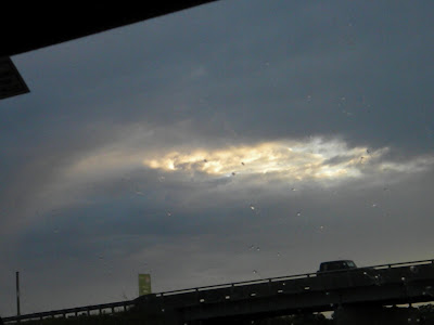
To end the day God gave us a beautiful sunset! So grateful for a glorious sight.
Sunday, June 3, 2012
6/2/2012
Waking up at 5:00 a.m. central time after 2 hours of somewhat resting sleep, I am reassured that God is so great through the window. The sun is beginning to rise over a clear sky! We left the Springfield Missouri area around 7:30 a.m. heading toward one of the most tragic natural disaster areas in 2011, Joplin Missouri. As we entered the city you could already tell that most of it was just recently rebuilt. However, there were many areas that are still working. The high school is in complete ruble and St. John’s Mercy Hospital has only its bare frame. I couldn’t imagine what these people were thinking when they saw a massive mile wide tornado heading in their direction. Over a hundred people lost their lives due to this disaster; but God has definitely blessed the city with the ability to rebuild.
As we continued through our journey, we crossed over Keystone Lake. Throughout the area you could see signs of recovering drought.
Entering Oklahoma we saw the Tulsa skyline, but as we moved West out of the city the Gloss Mountains made for an amazing sight of God’s artwork. These mountains are located in and around Red Rock City, Oklahoma. Farmlands have changed over to ranchlands and irrigation fields. Oil rigs also made an appearance almost every few hundred feet. Moving further West into Woodward City, Oklahoma vegetation changes to scrub grass and windmill farms were also becoming more common. Poverty has also become clearer, noticing the dying towns and dirt roads.
Throughout the afternoon parts of eastern Colorado and western Kansas were issued a meso convective outlook box discussing a possible watch being issued. Storms began to fire very quickly, but a gust front also formed out ahead of them starting a slight weakening trend. These storms were too far north of where we were located causing us to miss a lot of action. Many severe thunderstorm warnings were issued and a few tornado warnings were also issued, about this time were already made the decision to head back east for tomorrows chase.

Rebuilding God's House!

What's left of St. John's Mercy Hospital


What is left of Hope High School
Friday, June 1, 2012
06/01/2012
We left Muncie Indiana around 11 a.m. heading toward Springfield Missouri. As we traveled through Illinois I got to see the Gateway Arch. Clouds in the sky were stratocumulus with a few breaks of sun. The physical geography around me was also changing from corn fields to rock sediment hills. As we entered Missouri we crossed the Mississippi River and the weather changed, showing a slight outflow. Brief showers took place. After reviewing thoughts about where we should head for tomorrow, we decided that we are heading toward the TX panhandle.


Tuesday, May 29, 2012

Subscribe to:
Posts (Atom)